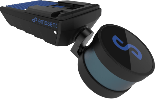
Hovermap ST

Hovermap ST is a SLAM-based multipurpose mobile LiDAR scanning solution capable of survey-grade mapping and georeferenced point clouds with autonomous functionality.
Hovermap ST – Simultaneous Localization and Mapping (SLAM)
Hovermap ST improves the accuracy of common mapping tasks and can be used with GCP to create survey-grade scans for long linear objects or feature-sparse environments that were previously challenging for other SLAM-based systems
Compact design
The compact and lightweight design makes it easy to carry when scanning on foot and offers longer flight time when used with a drone.


Georeferenced point clouds & survey-grade control
Hovermap ST’s precision engineering, Emersent’s best-in-class Simultaneous Localization and Mapping (SLAM), and automated ground control capability deliver dense, shadow-free, survey-grade point clouds of entire assets. Ground control also automatically georeferences point clouds to survey control.
Weather Resistant
Rugged, weather-resistant, and IP65-rated, the Hovermap is dust and splash-proof so that you can create maps in harsh environments, rain or shine. In addition, Hovermap’s moisture resistance makes it ideal for use in underground mines.

Autonomous Tap-To-Fly
Hovermap ST’s Tap-To-Fly capability enables exploration of previously inaccessible areas beyond the line of sight and communication range, as well as access to unprecedented information from a tablet. Omni-directional collision avoidance, guided scanning, and intelligent return-to-home capabilities ensure assets remain secure and valuable equipment is not damaged or lost.
Hovermap ST streams a live point cloud to the Hovermap app and previews the data in real-time as it is collected within communication range. That way, you can leave the site knowing you’ve covered everything you need.
Autonomy Levels

Mobile Mapping Mode
Mapping mode provides fast, accurate, high-resolution mobile scanning of environments where drone autonomy is not necessary. In addition, Hovermap ST’s quick-release mechanism allows you to easily switch from a drone to handheld scanning.

Pilot Assist Mode
Pilot Assist Mode offers omnidirectional collision avoidance, GPS-denied flight capability and stability control, providing confidence and stability for accurate and thorough inspections. It acts as a safety bubble for your drone, protecting the asset and your equipment.

Autonomous Waypoints
Autonomous Waypoint Mode enables beyond-line-of-sight flights through Smart Waypoints and guided exploration. Just tap on the map to set smart waypoints, and Hovermap ST will take care of the rest, navigating to the waypoints and mapping the area while keeping itself and the drone safe from obstacles.
Specifications
Collapse Hovermap
Hovermap ST Physical
| Hovermap Physical Specifications | |
|---|---|
| IP Rating | IP65 |
| Weight | 1.6 kg (3.63 lb) |
| Input voltage | 14 – 54V, powered from a battery or auxiliary power input |
| Deployment |
|
|
Supported drones |
|
| Quick-release mounting mechanism | Yes |
| Auxiliary port | Proprietary connector |
| USB port | Yes |
| WIFI Antenna | Internal |
Autonomy
| Hovermap Autonomy | |
|---|---|
| Flight Modes | Pilot Assist
|
| Autonomy Level 2 Waypoints |
|
| Autonomy Level 2 Navigation |
|
| Autopilot Compatibility | DJI & ArduPilot (Acecore Zoe) |
| Omnidirectional Collision Avoidance | 360° x 360°; size of an obstacle > 2 mm (5/64 “) wire; range 1.2 to 40 m (3.9 to 131 ft); In-flight adjustable safety distance |
| Included Accessories |
|
| Optional Accessories |
|
Mapping
| Mapping | |
|---|---|
| SLAM Mapping | Simultaneous Localization and Mapping (SLAM) based LiDAR mapping +/- 0.03% drift |
|
LiDAR accuracy |
+/- 30 mm |
|
LiDAR range |
0.40m to 100m |
| Mapping accuracy |
|
| Start / stop scanning while in motion | Yes |
| Angular field of view | 360° x 290° |
| LiDAR Data acquisition speed |
|
|
Maximum data capture traveling speed |
|
| Outputs |
|
| Point cloud file format |
.las, .laz, .ply, .dxf, E57 |
| Point cloud attributes | Intensity, range, time, return number (strongest & last) and ring number |
| Processing parameters | Pre-set profiles with 20+ adjustable parameters |
| Storage | 512 Gigabytes – approximately 8 hours of sensor data |
| USB 3 | High-speed data offload |
| Operating temperature | -10 to 45°C (14 to 113°F) |